Maps are used for more than just navigation these days. The citizen science projects highlighted below use maps to study topics ranging from wildlife to hydrology.
You can find even more mapping projects via the SciStarter Project Finder.
Cheers!
The SciStarter Team
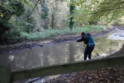 Share a Flood Observation
If you see a flood of any size or kind in the United Kingdom, researchers want to know! Contribute your observations to a flood events map that is publicly accessible online. Get started!

OMEGA-Locate
Small crustaceans are part of the fossil record in many aquatic systems, and they can provide information about past environmental and climatic change. You can contribute to the research of these fossils by validating geographic data. Get started!
 Whale mAPP
Many marine mammals are impacted by human activities like pollution, shipping, and fishing. To map the effects of humans on marine life, Whale mAPP volunteers record boat trips and animal observations. The project’s data are accessible to everyone! Get started!

Geo-Wiki Project
Scientists in fields such as forestry, ecology, and hydrology use land cover maps in their research, and it’s essential that their information is accurate. With your help, the project can analyze aerial images to update global land cover data. Get started!
 Crowdsourcing for Landscape Change
In order to keep our maps up to date, we need to track changes in land use. In this project, you’ll compare aerial images of Hampshire, England from 2005 and 2013 in order to record landscape level changes.
Get started!